Drone Solutions for Highway Monitoring and Planning
Explore how drones are revolutionizing highway projects with advanced technology and efficient solutions.
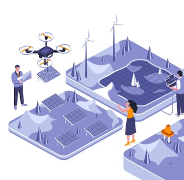
We deliver precise drone-based data solutions for highway planning, construction, and maintenance. Our aerial surveys help engineers, contractors, and authorities save time, reduce cost, and enhance safety during each stage of the project.
Aerial Drone Solutions for Planning Highway
Route Planning & Corridor Mapping
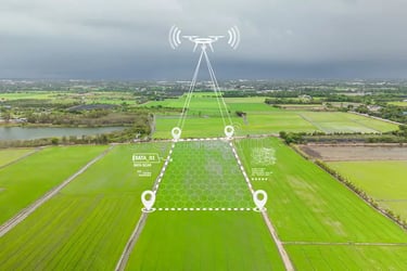
Conducting pre-construction aerial surveys for alignment planning.
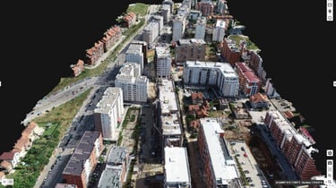
Mapping highway corridors with centimeter-level accuracy.
Generating high-resolution Ortho mosaic maps and elevation models.
Identifying potential obstacles, encroachments, and environmental constraints.
Analyzing alternative routes for cost and environmental efficiency.
Surveying existing roads for widening or extension planning.
Assessing topography for bridge and tunnel locations.
Integrating drone data with GIS for precise alignment design.
Creating cross-section and longitudinal profiles for design engineers.
Evaluating accessibility and approach road options.
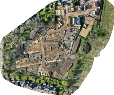
Construction Progress & Quality Monitoring
Real-time progress tracking of earthworks, bridges, and drainage structures.
3D modeling of ongoing work for contractor verification.
Comparing drone survey data with design drawings (as-built vs as-planned).
Monitoring grading, compaction, and material laying activities.
Documenting construction milestones and work completion.
Detecting structural defects early using high-resolution imagery.
Stockpile measurement for construction materials.
Monitoring worker and equipment deployment across large stretches.
Creating weekly or monthly visual progress reports.
Reducing site visits with live monitoring through drone feeds.
Pavement & Structural Inspection
Assessing surface cracks, potholes, and deformations on pavements.
Inspecting bridges, flyovers, culverts, and retaining walls.
Detecting drainage or shoulder damage after heavy rains.
Identifying faded road markings and signage deterioration.
Inspecting lighting poles and traffic signal structures.
3D scanning of overpasses and underpasses for maintenance records.
Detecting erosion or slope failure on embankments.
Monitoring the condition of median dividers and guardrails.
Inspecting bridge expansion joints and bearing conditions.
Documenting structural defects for repair prioritization.
Traffic Flow & Safety Management
Mapping traffic movement at intersections and toll plazas.
Detecting congestion and bottlenecks using drone video analytics.
Monitoring lane utilization and vehicle density patterns.
Analyzing accident-prone zones using aerial perspectives.
Assessing visibility and signage placement for driver safety.
Supporting smart highway management systems with aerial data.
Emergency response mapping for incident locations.
Planning traffic diversion routes during construction.
Evaluating rest area layouts and parking zones.
Creating safety audit visuals for road safety assessments.
Maintenance & Asset Management
Routine inspection of highway stretches for damage detection.
Documenting maintenance activities with before-and-after visuals.
Monitoring vegetation growth along road shoulders.
Detecting drainage blockages and water stagnation zones.
Assessing the lifespan of pavement layers through repeated surveys.
Identifying encroachments along the right-of-way (ROW).
Managing roadside utilities (signboards, lighting, guardrails).
Using drone imagery for asset inventory management.
Supporting predictive maintenance using periodic aerial data.
Providing long-term data records for infrastructure lifecycle tracking.
Drone Benefits
Explore how drones simplify highway projects for authorities and organizations.


Drone Assistance Highway
Discover the advantages of using drones in highway projects to streamline operations and enhance efficiency for highway authorities.


Highway Drone Support
Learn how drones can assist highway organizations in various tasks to improve project management and overall effectiveness.

Using drones in highway projects has made our work much more efficient and accurate.
John Doe

The drone technology has revolutionized the way we inspect and monitor our highways.
Jane Smith

★★★★★
★★★★★
Copyright © Inspired-robots 2024-2025. All Rights Reserved.
Inspired Robots Unmanned Systems (OPC) Private Limited
Stirring minds
Kundan mansion,2-A/3, Asaf Ali Road, Turkman Gate, Chandani Chowk, New Delhi, Delhi 110002
info@inspired-robots.com
+91-9821653324
Legal
custom machines for your unique solutions